Energy
Satellite data can provide valuable information within the energy sector in various ways. Data with an increasingly higher spatial and temporal resolution provide the basis for information products and services that can help managers and contractors in various applications and development phases. These vary from exploration and construction, raw material extraction, production predictions and the final distribution/transport to monitoring the effects of energy production on ecosystems. NSO is investigating the opportunities for satellite data within the various types of energy as well as each link in the energy chain.
Current applications of satellite data in the energy sector include:
Determining the risks posed by gas pipelines in the vicinity of houses as a result of subsidence
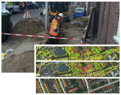 Due to subsidence of streets relative to houses, there is a risk of gas pipelines rupturing. Whereas in the past standard checks would have been carried out, these are now performed using deformation measurements from satellite data. With this new approach, gas pipes can be replaced more accurately. Therefore, smaller and consequently cheaper replacement projects can be carried out that minimise the inconvenience caused in the neighbourhood. Furthermore, this approach increases safety.
Improving predictions for wind energy
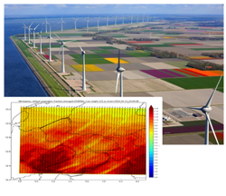 Surface roughness is an important factor in the modelling of the wind supply for onshore wind parks. Wind speed is reduced by buildings and vegetation. Surface roughness as a consequence of vegetation also depends on the type of crop and the growth phase. Satellite data are highly suitable for mapping these buildings and vegetation and any changes they undergo. Improved wind predictions will give wind parks, energy supply companies and grid operators the possibility to respond better to fluctuations in the energy supply. This in turn will give a safer energy network that will be less dependent on fossil fuels as a backup.
Monitoring the work around gas pipes
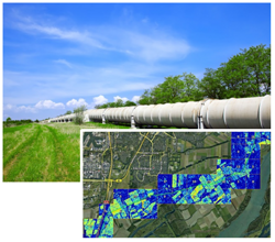 The gas industry strongly depends on a quick and safe pipeline network. However, incidents around pipelines regularly occur that have major safety, environmental and financial consequences. Nearly half of these incidents are the result of activities carried out by third parties. These activities can be carefully monitored with the help of satellite data. Helicopter monitoring is then no longer needed and the application also reduces the current information gap between the working field and the office.
If you are curious to know whether satellite applications could have added value in your work environment, please contact:
Coco Antonissen
E c.antonissen@spaceoffice.nl
T +31 6 21 33 99 74