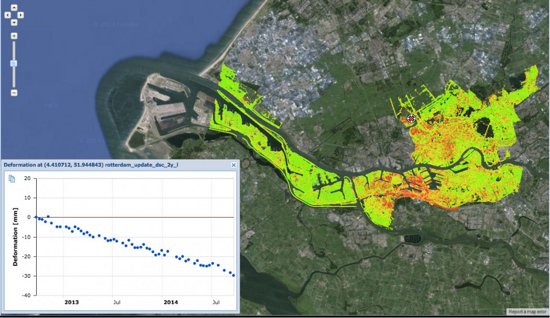
Soil movement
The soil moves. This is due to processes in deeper layers of the Earth, but also due to settling, water management, earthquakes and human interventions. In the Netherlands, this mainly concerns clay and peat areas. Built up areas, the extraction of groundwater, the flooding of old mines and the extraction of raw materials can cause the soil to rise or sink.
Rijkswaterstaat and the Ministry of Economic Affairs and Climate are examples of Dutch governments for which data on soil movement are important. Think of monitoring roads and dykes, or mapping soil movements due to (former) mining activities.
Beeld: SkyGeo
Satellite data can be used to map soil movement. Radar missions can even observe movements of several millimetres per year. The Dutch government purchases satellite data centrally and then makes this available free of charge to interested parties via the national Satellite Data Portal.
If you are curious to know whether satellite applications could have added value in your work environment, please contact:
Coco Antonissen
E c.antonissen@spaceoffice.nl
T +31 6 21 33 99 74