'A strong local partner is critical to success'
Fons Nelen, co-founder of IT agency Nelen & Schuurmans.
The Netherlands invested in the Geodata for Agriculture and Water (G4AW) programme for ten years. In this series, key players look back and look to the future. Fons Nelen, co-founder of IT agency Nelen & Schuurmans: 'Geodata and digitalisation were central from the beginning. That was new in development cooperation.'
Your company Nelen & Schuurmans was involved in seven different G4AW projects. What contribution were you able to make?
'We are an IT and consulting firm with specialist knowledge in the field of water management. Our clients include provinces and water boards that want to map risks of dyke breaches or flooding. Within G4AW, we had the role of system integrator. We work with existing satellite data and other data sources. We analyse, combine, and model thereby creating added value. Other parties then get to work developing customised applications using our analyses and models.'
That still sounds pretty abstract. Can you give a concrete example?
'If you want to create a flood warning system in the Netherlands, you need to know more than just how much rain is going to fall. Where does water accumulate? Which streets will be flooded? Which hospitals will remain accessible? The same applies to the issues of G4AW. For instance, you can use satellite data to determine land use, soil moisture, evaporation and water availability in an area. But then you have to combine this data, analyse it and provide it with local context to give advice. In this, G4AW has shown vision: do you really want to help food producers? Then you have to understand their local context and get a whole chain of parties to collaborate on a solution.'
In what way did G4AW differ from other development aid programmes?
'Many government subsidised programmes deal with major transitions and focus on governance. With G4AW the user with a need and technology as a tool were central from the start. That was absolutely new in the world of development cooperation. And it was attractive to us: we could contribute our expertise. At the same time we ourselves learned a lot from our participation in this programme.'
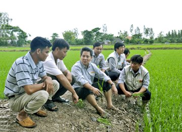
©LocTroi/Sat4Rice partnership
What was the most important lesson the programme taught you?
'That you have to pay enough attention to cultural differences. Take Sat4Rice, a project in Vietnam's Mekong Delta. We sat at the table with the director of one of the region's largest rice companies. It was crystal clear to us that analysis with satellite data would add value for his company and its customers, the rice farmers. But can you really convey that with a language barrier and without specific knowledge of their business model? With poor knowledge of the country, political culture, and other local customs? Since G4AW, we are convinced that you need a strong local partner with whom you can build a relationship. That is crucial for success.'
Because only with such a local entity can you reach the end users properly?
It is a necessary condition. Although even with such a party you obviously have no guarantee of success. The first version of the Sipindo app, developed in the SMARTseeds project for small food producers in Indonesia, immediately reached a hundred thousand farmers. It came with seeds and other agricultural supplies. But we found the geo-information behind it relatively poor. You can compare it a bit to a travel agency passing on the weather forecast to holidaymakers. That's a nice feature but very limited. We know that the added value of geodata, if applied properly, is much greater. We sometimes still have to convince local partners of that. With Sipindo, we are only succeeding now, four years later.'
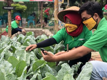
©SIPINDO/SMARTseeds partnership
G4AW has ended. Does this also apply to your involvement in the project regions?
'On the contrary. Enduring contacts have emerged from the SMARTseeds programme in Indonesia. A local IT company uses our Lizard data warehouse and analytics platform to enrich the app with information. We are teaching them how to work with geodata. And in Vietnam, we will develop a data centre for the Mekong Delta with a local partner with support from the World Bank. The experience we gained with G4AW plays a crucial role in this. We came across this project thanks to a Vietnamese IT company. They understand our IT products and we are interesting to them because we are willing to share our technology with them and develop business together.'
What could participants in the target countries do to make a subsequent programme even more successful?
G4AW has shown that services based solely on satellite data never reach the level of detail needed by smallholder food producers. The methodology would really take off if farmers themselves started collecting data. Hyper-local data on precipitation, soil moisture, soil composition, crops, and more. You sometimes hear: no satellite application beats the farmer's view of his field. That is true, but the farmer does not know what is happening beyond his field. You have to reconcile those two perspectives, and that is where digital technology and geodata play an important role.'
How could the Netherlands make an even greater impact in the next initiative?
'We could focus even more on earning power and innovation policy. The Netherlands is still quite fragmented in this area. There are many parties, many young companies doing "something" with geodata. But at the political level there is no strategy yet to strengthen the export of specialist IT services. G4AW has definitely been a catalyst for technology development but each project included only one or two technology companies. A next step could be to focus on more integrated services. Relatively small players can develop new services together, as happens for instance at Brainport Eindhoven or ASML. The key, also in the Netherlands, is cooperation. We need to act together to distinguish ourselves on an international level.'