Soil displacement surveillance from space
Construction waste or soil is not always clean enough to simply reuse elsewhere. Yet that sometimes happens. Satellite imagery can help to better detect these types of environmental crimes. Commissioned by the National Police and in collaboration with the Human Environment and Transport Inspectorate (ILT), the Terravisie 2.0 project is further developed.
For example, if a road is widened or a dike is raised, soil and building materials are usually reused for this. “Of course only as long as it is not too polluted for reuse”, emphasizes René Overduijn, who works at the ILT of the Ministry of Infrastructure and Water Management. “This involves inspections, certificates, notifications and permit conditions. When such a construction project starts it is monitored, but by no means all construction projects are reported. So we don't always know what is going on, and where." It is estimated that there are about 350,000 soil displacements per year. “We want to gain a better understanding of those soil displacements, so that we can improve supervision and identify and adjust malpractice on time.”
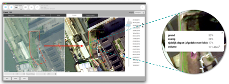
This is where satellite imagery is going to help. They can detect soil displacements from 50m3. Using both optical and radar data, smart software applications can calculate the size of soil piles. To do this, images taken at different times are compared with each other. The difference indicates how many cubic meters of material it concerns. A number of companies developed this application in an innovation project that the NSO started in 2018 and completed last year. This Small Business Innovation Research (SBIR) was commissioned by the National Police and the ILT.
More efficient monitoring of large-scale soil displacements can prevent environmental crime, through early warning systems for the inspection services. “It is also possible to effectively look back to re-investigate,” explains a police spokesperson on behalf of the Thematic Investigation Department. “Checks on soil operations often only take place once the work has already been completed. Then it is no longer possible to verify what happened exactly. Looking back with satellite data is useful: you simply check the satellite images. A granted permit or notification is based on the amount of soil, storage requirements, a specific location, and so on; do the visible activities match? Is it soil or is it a specific building material?”
This last question mainly concerns the usefulness of the follow-up Terravisie 2.0, which has now been started on behalf of the National Police. “The ability to distinguish between different building materials improves if the software is trained in this with data from old cases.” The police spokesperson mentiones the automatic classification of ash from burned household waste, oven residues from factories, thermally contaminated soil, steel slag, sand and asphalt granulate as examples. Three companies will further develop the software using data provided by ILT: Sobolt
Screenshot of TerraVisie 2.0
(Rotterdam), S[&]T / Orbital Eye (Delft) and 52impact (Rotterdam). René Overduijn (ILT): “The main goal is to obtain information from cases that are known to us and that have already been in the publicity. The comparison of weekly scans of two large and two small areas in the Netherlands should provide sufficient training: new material can be found here; what is it and where could it come from? Additional information is retrieved from various sources.”
Terravisie 2.0 started last December. The aim is to deliver an easy-to-operate application by the summer of 2023, with which end users can quickly and accurately identify locations, (building) materials and quantities. “Inspectors will then soon be able to set out with a lot of research material in their hands,” expects Overduijn.
The Dutch police expects that the 450 people of the environmental department will investigate more, with less administrative work. “I think we will be able to easily bring more things to a successful conclusion. And hopefully that will also have a discouraging effect!”
The NSO regularly issues SBIRs. An SBIR (Small Business Innovation Research) brings together market parties from the EU and the Dutch public sector to develop applications for well-defined themes in which satellite data is used. Here you can find more information.