Satellites assist with efficient landscape management
Rows of trees, bushes, hedges and ponds: minor elements such as these give our landscape their character and quality. The Ministry of Agriculture, Nature and Food Quality (LNV) is looking for ways to protect these landscape elements, because they add cultural-historical value to the landscape and improve its biodiversity. To so do, however, they must first be mapped. This task can be made easier with the help of satellite technology.
How many of such small landscape elements do we have? Where are they located? How are they doing? In truth, there is much we do not know. This lack of knowledge is mainly due to the fact that most of the landscape elements that have been mapped are the ones for which a small number of farmers receives a European subsidy for so-called "agrarian nature management.” To make sure these subsidies are earned, the aerial photographs that the government has made of the Netherlands twice per year are examined, sometimes combined with a visit from an inspector.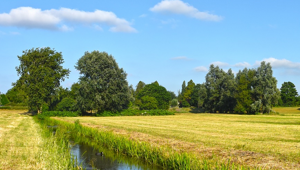
Landscape elements such as small groups of trees can be distinguished from other landschape elements like hedges and ponds based on satellite imagery.
However, mapping every single landscape element using this “manual” technique would be (too) costly. The Netherlands Space Office (NSO) and the Ministry of Agriculture, Nature and Food Quality (LNV) realised there was a smarter approach with the help of satellite imagery. In collaboration with the Netherlands Enterprise Agency (RVO), a new project was launched last year. It has been making steady progress ever since.
Greener agricultural policy
“This allows us to better protect the small landscape elements that no one had been paying any real attention to these past years,” says Frans Lips of the Ministry. “It saddens me greatly that the landscape elements are at risk. It not only negatively affects the quality and cultural-historical value of our rural regions, but also impacts the biodiversity. Just think of all the insects that live there. Perhaps, if our government decides to do so, the subsidised management of these landscape elements can become a more prominent part of farmers’ income.”
That is one of the reasons why the RVO is involved in this innovation project. RVO advises farmers and oversees the implementation of agricultural subsidies. Dick Oele, a consultant at the RVO, says: “The Netherlands wants to implement the European Common Agricultural Policy in a 'greener’ manner. This can include the preservation and management of small landscape elements. If we decide to do that, we need to monitor the landscape elements, such as rows and groups of trees, ponds, hedgerows, etcetera, more closely. At the moment, we do not know where such elements are vanishing, because only around 18,000 of an estimated three million elements have been identified as such and are being monitored. We may be able to improve this process with the help of satellite data.”
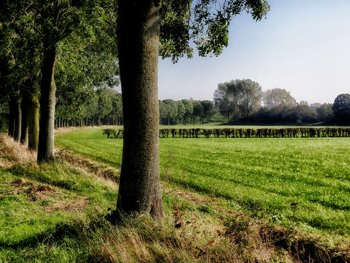
Landscape elements add cultural-historical value to the Dutch landscape and improve the biodiversity.
Doing more for less
In early 2020, LNV, RVO and the NSO selected four companies to conduct a feasibility study with regard to the identification, monitoring and registration of small landscape elements in rural areas. Two of these parties - a consortium formed by Arcadis and TerraSphere and a consortium formed by 52Impact and Geronimo.AI - were recently invited to further substantiate their proposal. They will move on to "phase two” of the SBIR programme ("Small Business Innovation Research"). With this programme, the NSO stimulates businesses to develop a new type of service that uses satellite data as a key component. “From the looks of it, we will be able to monitor many more landscape elements for far less money by 2021 than we would be able to with the current method.” That is the preliminary conclusion of NSO project leader Coco Antonissen after seeing the first of the four initial presentations in early July.Although each of the businesses has opted for a slightly different approach, they all utilise a combination of data sources, including satellite data, and work towards the same goal: automatically identifying landscape elements across the entire country. Using satellite imagery with an accuracy of just fifty centimetres, which covers the entire country and is produced much more frequently than the aerial photographs, any changes to these elements are automatically monitored. Users such as the Ministry of LNV and the RVO can easily retrieve whatever data on the past or present they may need.