Water authorities use satellites to monitor drought
In the Netherlands, we now have unprecedented insight into how wet or dry the ground beneath our feet is. Detailed data are available for the entire country - from space, no less. All Dutch water authorities and Rijkswaterstaat have access to the same source: OWASIS. It gives water managers better insight into the amount of water in the ground. With this information, they can take appropriate measures, especially when extremely wet or dry situations are predicted.
The fact that the Netherlands is very dry should come as no surprise. Neither should the fact that it can rain very hard very suddenly and that such showers can create a ton of problems. In many places, the ground is so dry at the moment that water rapidly flows away instead of being absorbed. In the Netherlands, climate change has resulted in more extreme weather: more heat waves and heavier showers, even in wintertime. When the rivers and sewers cannot contain the water anymore, the water authorities face the question of if and where pumping stations, locks and/or barrages must be used. With OWASIS, they now have more insight into the areas where the ground can or cannot absorb large volumes of water. This allows water managers to work together to direct water to areas where it will cause the least amount of hindrance or where it is needed most.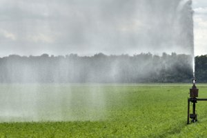
Drought in 2018 and 2019 forced farmers to irrigate more than in other years. It seems like 2020 is going to be a dry year again. Source: Flip Franssen
Satellites instead of pipelines
In the Netherlands, the water authorities are responsible for water barriers, water quality and water volume. They manage the surface and ground water levels and use those to determine how suitable our country is for residential, agricultural, recreational and construction purposes. By affecting the water level with locks and pumping stations, they can manage the water balance. After all, too much or not enough water can lead to hindrance or damage. To be well prepared and properly cope with extreme situations, several important questions must be answered: how moist is the ground? How much moisture is available to our flora? How much water can we add temporarily? The water authorities have been managing the water level for centuries. In our modern age, this can be done with satellites. If those satellites feature radar technology, even heavy clouds are no obstacle.
Joost Heijkers, hydrologist at Hoogheemraadschap De Stichtse Rijnlanden from Houten is thrilled: “This marks the first time in the history of the water authorities that we have detailed knowledge of soil moisture, evaporation and ground water levels - not only in the here and now, but also days into the future and not only for our own region, but for the whole of the Netherlands. With OWASIS, our sector is better equipped to direct water in the right direction without any unnecessary pumping. OWASIS is an alternative for the far more costly use of e.g. thousands of additional ground water monitoring wells.”
Dashboard
Satellites observe and measure on a daily basis; for OWASIS, this concerns a number of factors pertaining to water on and below the surface of the earth. A computer program translates these measurements into insights into e.g. the amount of ground water evaporation. Together with meteorological data, all that information is combined every day into the so-called National Hydrological Model. Water specialists use that model to study the behaviour of ground water and surface water streams. Water and IT company HydroLogic from Amersfoort links all the data together and adds an essential aspect, says Director of Technology Maarten Spijker. “We translate all available data into a dashboard for the client. At a glance, these information displays show the current situation and how best to deal with it. Every morning, this gives water authorities up-to-date insight into the water balance and potential issues that may arise today, tomorrow or the day after tomorrow.” It is also possible to make comparisons with statistical data from as many as fifty years ago to see how much drier or wetter than normal the current situation is.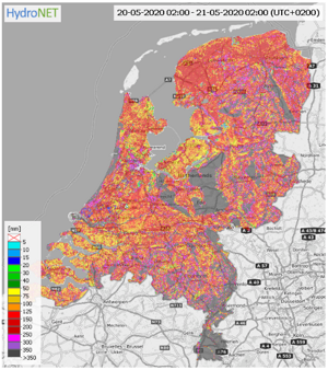
The dashboard shows that soil was already dry on May 20th.
These past few years, a significant number of water authorities has tested the OWASIS system and it is now available for all twenty-one Dutch water authorities. For the time being, this is done as part of the “Smart Water Management” programme in which water authorities and Rijkswaterstaat work together to develop methods to reduce water hindrance and shortages by more effectively distributing the available surface water in the Netherlands.
The state-of-the-art OWASIS system is also interesting for other sectors in the Netherlands, such as the drinking water sector and research institutions. The parties involved see concrete export opportunities to Germany, Belgium, South Africa, Colombia and Australia, which all face similar issues.
Water specialists
OWASIS was developed with support from the NSO via the ESA-BASS programme (Business Applications and Space Solutions), which was introduced by the European Space Agency (ESA) to market sustainable satellite services and products. Netherlands Space Office (NSO), which executes the Dutch space policy, facilitated the Dutch water specialists since 2013 with the feasibility study and the demonstration phase using more than half a million euros from the ESA-BASS programme. Joost van Uum, programme coordinator at the NSO: “Satellite data are an important source of information that has myriad social applications, including water management. OWASIS is an important and promising step in the use of satellite data. NSO is happy to stimulate that.”