Europe and the Netherlands make Copernicus satellite data more accessible to boost use
The European Commission is making its Earth observation programme Copernicus more accessible to users across Europe. It is doing this with a central platform for all satellite data, thematic 'hubs' and national stimulation activities in European Member States. This will allow governments, businesses and citizens to better exploit the great potential of satellite data.
European satellites provide valuable data that is freely and openly available day by day. So far, the Sentinel satellites and other missions of the Copernicus programme collected 34 Petabytes of data on land, water, ice and air. Over 600,000 people have since made use of this. But the potential is much greater still, the European Commission believes. With three specific activities, it wants to better meet the needs of end users and lower the threshold for using satellite data and derived information products.
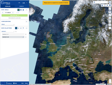
Copernicus Data Space Ecosystem.
Central data platform
Since the end of this year, there has been one central place: Copernicus Data Space Ecosystem where all Copernicus satellite data can be found. For example, radar data to monitor dyke failures, air quality measurements that reveal greenhouse gas emissions and measurement data that help predict where the greatest risk of flooding is after heavy rainfall.
The central data platform has been made as user-friendly as possible. It offers the option of downloading data directly or, conversely, analysing it in the cloud. This saves a lot of storage space on local computers and makes the processing of raw data into usable products significantly faster.
Thematic hubs
Raw satellite data can be processed into information products for users. These products have so far been categorised into six services: land, atmosphere, marine, security, emergency and climate change. A logical subdivision if you think from the supply point of view. With the introduction of thematic 'hubs', on the contrary, thinking from the demand side: Copernicus puts the user's needs first.
Take the Health hub, for example. This is a one-stop shop for all data, products and information related to this topic, such as temperature maps, monthly ozone concentrations, or suitability maps for tiger mosquito settlement. This is the place to go for users who want to map air pollution, fight diseases or research heat stress, for example. In addition to the Health hub, three more thematic hubs were launched late last year: Energy, Arctic and Coastal Areas. More hubs will follow in the future.
![]() National outreach activities
National outreach activities
A number of Dutch governments and companies are already using the possibilities offered by satellite data. But the potential of this data is many times greater, stresses Mark Loos of the NSO: 'We need to raise awareness of the application possibilities of satellite data and sometimes adjustments are needed to be able to use data properly at national level. This is what we will work on in national programmes, together with the space sector.'
The first topic that the Netherlands will work on is the atmosphere. NSO is doing this together with TNO, KNMI and RIVM. 'Currently, many atmospheric information products have a resolution of ten kilometres,' says Loos. 'We want to refine these to 1 to 2 kilometres, making them more compatible with Dutch models. This will allow us, among other things, to improve air quality forecasts and conduct more accurate research into the largest sources of air pollution in our country.' In 2024 and 2025, the Netherlands will also start national Copernicus programmes on the themes of land, marine and climate change.
Promoting the use
According to Loos, the Copernicus programme has 'come of age' in recent years. A lot of energy, time and money has been spent on building up the programme. Now is the time to reap the benefits: 'The opportunities offered by satellite data, also for Dutch governments and companies, are enormous. If we want to cash in on these opportunities, we need to stimulate the use of satellite data with various activities, and make the data even more insightful, accessible and usable for more users. This is what we will do in the coming years with Copernicus' central data platform, the thematic hubs and specifically Dutch activities.'
Governments, companies and other parties who have questions about the potential of satellite data or ideas about its use can contact NSO. NSO represents the Netherlands in the Copernicus programme.