Measuring water levels with small radar satellites: promising but 'quite complicated'
Scientists and companies will develop small radar satellites that can measure water levels. The NSO supports the next step in the development of these Alticubes with funding from the Ministry of Education, Culture and Science.
'Quite complicated' is how Rens Swart calls the technological development. Swart is Alticubes' daily project manager. Radar is a complex technology, and it is extra difficult to build it in a CubeSat, a small satellite the size of a few milk cartons.
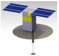
Preliminary design of an Alticube. Source: TU Delft
In the project, TU Delft, Robin Radar, ISISpace and Swartvast are working together to develop the Alticubes. The idea for the altimeters stems from a previous collaboration. Typically, space radar instruments are large and expensive. The Netherlands does not have all the knowledge to build a large radar satellite, but the researchers saw that the expertise to build small radar satellites does exist in the Netherlands. The scientists investigated how the Netherlands could contribute that expertise to social issues, which is how the idea for the altimeters came about.
Multiple small satellites
Small satellites also have advantages over large satellites, according to Swart: 'These small satellites are a lot cheaper, so you can launch more of them. The precision is less than that of a large satellite, but an advantage is that with multiple satellites you can take more measurements per day, or, for example, measure in two places at the same time.' The ultimate goal is therefore to have a swarm of small satellites in space.
Altimeters can measure the roughness of water.
In addition to the height, a radar altimeter also measures the 'roughness' of the water. That says something about the wind: on very still water the altitude is the same everywhere, but with strong wind and high waves there are greater differences in altitude. The Alticubes can be useful in the marine, the offshore industry and in oceanography, to monitor ocean currents. Or in monitoring coastal areas, where high spatial resolution is important to measure the difference between land and water.
Swart also sees many opportunities in monitoring inland waters such as lakes. 'We cannot measure this at the moment, but hopefully this will be possible in the future with a constellation of altimeters. We are currently investigating this. In the Netherlands the monitoring system is very well organized, Rijkswaterstaat can see exactly how high the water is in important waters at the touch of a button. The Netherlands is quite unique in this respect, other countries often have a less good monitoring system. If we can measure this from space, we can export the knowledge and capabilities.'
New consortium
The idea for the Alticubes arose in the radar technology expertise network. With the expertise network programme, NSO and NWO promote collaboration between scientists in the space sector. In this follow-up project, the consortium will conduct more research into the applications and develop a prototype of the altimeter. Robin Radar is a new party in the network and comes from outside the space sector. Swart: 'We were looking for a partner to develop the electronics with us. Robin Radar has the expertise and manpower for this.'
In this project they work closely with project leader TUDelft and ISISpace, an expert in the field of Cubesats. The project will last two years and will deliver a prototype of the electronics and integration with the CubeSat.
NSO finances this project from the instrument programme. The instrument program is financed by the Ministry of Education, Culture and Science and aims to further develop promising concepts for scientific instruments up to a maximum of TRL6 (Technology Readiness Level).